Updated
Thailand flood map from NASA satellites: where the water is now
Gauges say how high a river stands, not how far the water has spread. This layer uses NASA's VIIRS satellites, which pass over the region several times a day, to show which land was under water in the last three days, on the same map as the gauges, so the levels and the flooded land can be read together.
Open the map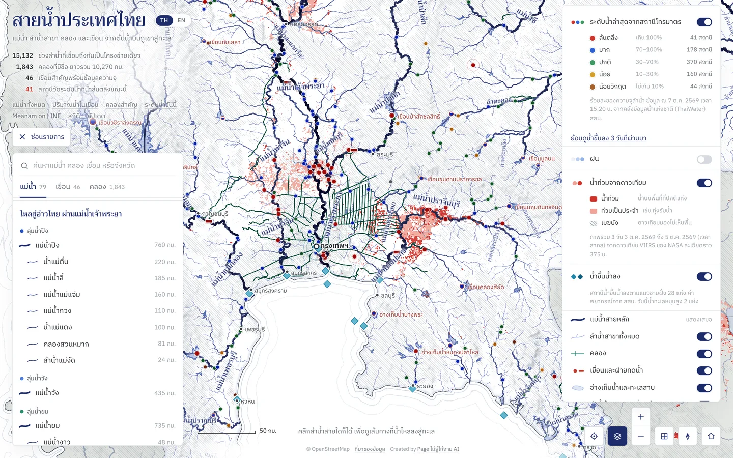
How to use it
Switch the flood layer on or off
Flooding seen from space is on by default. Switch it off or on under that name in the map's layers (the stacked-sheets button).
Read the colours
Red is water on land that is usually dry. Pink is land that floods most years, such as flood plains. Grey hatching is where cloud hid the ground on every pass, so nothing is known there.
Read it with the gauges
Zoom into the red and tap a gauging station nearby for its level, how far it is over the bank and its two-day chart. Red stations are over their banks.
Rain from the satellites
Under Rain, choose NASA satellites for a whole day's rain from the GPM satellites over Laos, Myanmar and Cambodia too, upstream on the Mekong and the Salween where Thailand has no rain gauges.
Good to know
- Three days at a time
- Each spot is what the satellites saw over three days. The dates in the layers menu are UTC, and the map runs a day or two behind.
- Cells of about 650 m
- The satellites see about 375 m of detail, drawn in cells of about 650 m, so the map turns blocky close in. Water in towns, under trees or in small plots may not be seen.
- Cloud in the rains
- These satellites cannot see through cloud, so in heavy rain much of the map is hatched. Read the gauges alongside.
Where the data comes from
The three-day flood map (VIIRS Combined Flood) and daily rain (IMERG) from NASA's Global Imagery Browse Services (GIBS), open for anyone to use. The site fetches them and keeps them for three hours.
Frequently asked questions
- Why is a flooded place not red on the map?
- It may be under cloud on every pass (grey hatching), water in a town or under trees that the satellites cannot see, or flooding newer than the latest images, which run a day or two behind.
- How is pink different from red?
- NASA separates land that floods most years, such as flood plains and paddies that take the overflow, from flooding that is unusual, so red is the one to watch.
- Can I decide to evacuate from this map?
- Not from this alone. Satellite images run behind and cannot see under cloud; follow local announcements and the Department of Disaster Prevention and Mitigation.